


Winter storm warning in effect March 2-3 for Highland County
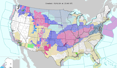
The National Weather Service has issued a winter storm warning Sunday, March 2 and Monday, March 3 for much of southern Ohio, including Highland County.
Periods of heavy snow and ice are possible from 1 a.m. Sunday until 1 p.m. Monday, the NWS said.
A winter storm warning means severe weather conditions are likely.
The National Weather Service said Saturday, March 1 that snow accumulations could range from 5-8 inches, with 1/10 of an inch or more of ice.
Forecast
Saturday night – Rain and snow likely before 4am, then snow and freezing rain likely. Cloudy, with a low around 30. Southwest wind 5 to 8 mph becoming north after midnight. Chance of precipitation is 70%. Little or no ice accumulation expected. Little or no snow accumulation expected.
Sunday – Snow, freezing rain, and sleet before noon, then snow and sleet. Temperature falling to around 22 by 5pm. North wind 9 to 13 mph. Chance of precipitation is 100%. New ice accumulation of less than a 0.1 of an inch possible. New snow and sleet accumulation of 2 to 4 inches possible.
Sunday Night – Snow, mainly before 4am. Low around 12. Wind chill values as low as -3. North wind around 14 mph, with gusts as high as 25 mph. Chance of precipitation is 100%. New snow accumulation of 3 to 5 inches possible.
Monday – A chance of snow, mainly before 7am. Cloudy, then gradually becoming mostly sunny, with a high near 20. Wind chill values as low as -4. North wind 11 to 15 mph, with gusts as high as 28 mph. Chance of precipitation is 30%.
Monday Night – Partly cloudy, with a low around 0. North wind 6 to 9 mph.
Tuesday – Mostly sunny, with a high near 28.
Tuesday Night – Mostly cloudy, with a low around 11.
Wednesday – Partly sunny, with a high near 31.
Wednesday Night – Mostly cloudy, with a low around 15.
Thursday – Partly sunny, with a high near 37.
Thursday Night – Mostly cloudy, with a low around 23.
[[In-content Ad]]