


Ohio’s first conservation district: Highland SWCD was the first, and one of 10 districts authorized in 1942
Lead Summary
By
John Kellis-
President Roosevelt once toured the Great Plains with some leaders telling him to just abandon the region and let it go. It wasn’t worth the effort. Roosevelt said he could see in the people’s eyes that they intended to stay and survive.
Hugh Hammond Bennett and other visionaries scheduled congressional hearings in 1935 on the creation of the U.S. Soil Conservation Service (SCS).
Later, as the enabling legislation was approved by Congress, Ohio finally passed legislation to authorize the formation of conservation districts on May 16, 1941.
Under the legislation, local communities were asked to create locally led conservation districts. As conservation districts were created by local citizens, SCS would have the authority to provide technical assistance through that district to the landowners, with the district supervisors overseeing the state and federal programs on behalf of those local land users.
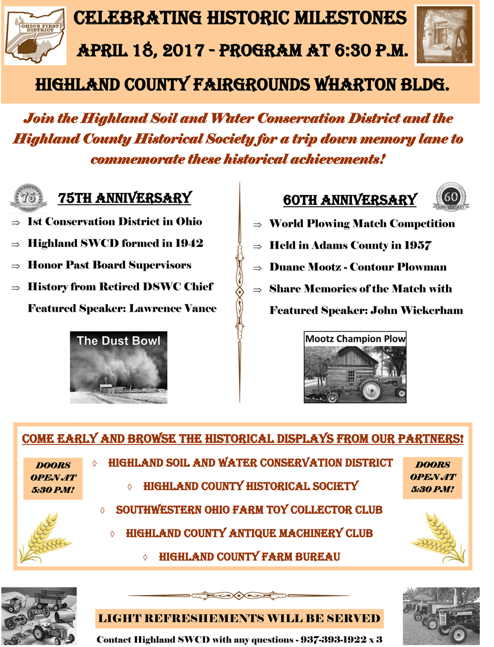
Highland County submitted its petition to the newly formed Ohio Soil Conservation Committee on March 25 1942. Seventy-two residents attended that hearing, supporting the formation of a district in Highland County. That petition being accepted, Highland County held the first required public referendum on April 18, 1942.
The enabling legislation required 75 voters to pass a petition, but Highland County registered 696 total voters, and it passed by a 70-percent affirmative vote.
Highland County became the first conservation district in Ohio on April 18, 1942.
There were several counties planning to create districts that year. Champaign and Clark counties held their referendums a week after Highland County, and by the end of the year, those three were joined by Butler, Coshocton, Morrow, Noble, Guernsey, Monroe, and Tuscarawas counties, for a total of 10 counties forming districts in 1942.
Later, in June of 1942, the first SWCD supervisor election was held in Highland County. Elected were Herbert Williams, chairman; Earl Surber, vice president; E.J. Cook, secretary-treasurer; John Beaver, member; and James Satterfield, member.
Finally, the first memorandum of understanding with the Federal Soil Conservation Service was signed and the work began. By the end of the decade of the 1940s, 80 of Ohio’s 88 counties had held their referendums and created Soil Conservation Districts, the last of the 88 forming districts was Lucas County in 1963.
On a state level, the supervisors of Highland, Clark, and Butler counties met in September 1943 to form an association to represent the interests of all the supervisors in the state.
They met, adopted bylaws and formed the Ohio Federation of District Supervisors, now known as the Ohio Federation of Soil and Water Conservation Districts. That private organization formed for the purpose of representing all district supervisors and guiding the formation and evolution of Soil and Water Districts in Ohio.
The conservation problem here in Ohio and the Corn Belt was not the wind erosion that had so dramatically defined the problems of the “Dust Bowl” across America’s Great Plains. Rather, the equally damaging issue in the Midwest was water erosion that was creating gullies so big they could hide a truck or a tractor.
Recognizing the problems and the practices that led to the problems took strength, resolve and most importantly, local knowledge and leadership. The solutions and the processes to adopt and install those solutions were painful to accept and took courage by all involved.
As the farmers and conservationists took on these challenges, they literally transformed agriculture across this country, making it a model for the entire world to follow. The genius of the movement was incorporating the locally led component, which the SWCD continues to bring to the table in 2017.
In the 1930s and ’40s, farmers were asked: 1.) to plow on the contour and to build terraces that slowed down the water runoff; 2.) to plant over 18,000 miles of windbreaks to help stop the wind; 3.) to leave crop residue on the surface; and yes, 4.) to turn the most fragile areas back to their natural state of native prairie grass.
Locally, farmers were building erosion control structures and healing the gullies created from poor rotations and bad water management. The country had made a pact with the American farmer: “We will help pay for the application of conservation practices if you will install them, maintain them and become better stewards of the land.”
Everyone should be proud of the fact that all of these programs remain voluntary today.
The decade of the 1950s saw significant progress in the conservation movement in Ohio as county commissioners were authorized to appropriate funds to assist districts which would be matched by the state. The 1954 Public Law 83-566, Watershed Protection and Flood Control Act, authorized small watershed projects through SCS.
In Ohio, the first two pilot projects were the Upper Hocking in Fairfield County and Rocky Fork in Highland County, as Highland County was again leading the way in Ohio.
That Rocky Fork Watershed Project brought Tom Parry here as the federal district conservationist for Highland County. He served the county on behalf of the SCS until he retired in 1974. His son, David Parry, became the district conservationist in 1978 and served Highland county for SCS (since renamed the Natural Resource Conservation Service) until 2006. Fifty years of service by the Parry family is to be admired and greatly appreciated.
The 1950s also saw a growth in district education programs with sponsorship of 4-H camps and the distribution of soil stewardship materials through area churches. In 1957, conservation offices and staff in and around Highland County co-sponsored the World Conservation Exposition and Plowing Matches held in Adams County. This was the first such exposition held in the United States and represents the largest such expo ever held in southern Ohio.
Conservation agencies worked for decades to complete soil surveys and publish them on a county-by-county basis. Highland county was surveyed from 1963-68, and the document was printed in 1977. These surveys represent perhaps the most intensive study of the land and the soils that has ever been undertaken. Soil surveys provided the basis for all land disturbing activities and fertilization for crop production. Citizens can access all the findings of the soil survey, and use its findings to guide their land-use decisions.
Highland County has always been a high priority for intensive land treatment practices and operations. Not so much that its farmers are that much more committed, but rather because geography and geology requires us to be more vigilant. Highland County sits right on the terminal of the great glaciers of North America. Land from Leesburg northward being dominated by row-crop agriculture, having been leveled by the glaciers. South of Hillsboro is unglaciated, steep wooded areas with fewer crops and more livestock. That border is an important region for conservation.
No-till and minimum tillage became the most dominant method of controlling cropland erosion in the decade of the 1970s. No-till was not an easy step for agriculture to adopt, but as chemicals and equipment refinements have continued, farmers have been able to increase yields and reduce input costs, to the benefit of the land in reduced soil erosion.
David Parry shared with me that in 1986 Highland County was awarded the State Conservation Farmer, the top no-till corn yield and the top no-till soybean yield in the state. These were significant accomplishment from a southern Ohio county.
Perhaps the single greatest advancement in private lands conservation was the passing of the 1985 Food Security Act (Farm Bill) as it was dominated by conservation provisions and led to many tools still in use today.
The Food Security Act designated acre-by-acre which land would be considered highly erodible (HEL) land. The act created the Conservation Reserve Program and increased the public commitment to help agriculture protect lands for future generations. Highland County was one of the leaders in the state with more than 25,000 acres of highly erodible land set aside in grasslands or trees through CRP.
The Highland Soil and Water Conservation District is constantly striving to help land users make good decisions with the land they are trusted to use. From education programs, to providing direct technical assistance to land users for conservation practices, the offices continue to help land users apply practices that prevent cropland erosion, manage our pasture and woodlands, enhance wildlife cover, and improve water quality.
Yes, the Soil and Water Conservation District is as relevant today as it was when created 75 years ago.
Hugh Hammond Bennett and other visionaries scheduled congressional hearings in 1935 on the creation of the U.S. Soil Conservation Service (SCS).
Later, as the enabling legislation was approved by Congress, Ohio finally passed legislation to authorize the formation of conservation districts on May 16, 1941.
Under the legislation, local communities were asked to create locally led conservation districts. As conservation districts were created by local citizens, SCS would have the authority to provide technical assistance through that district to the landowners, with the district supervisors overseeing the state and federal programs on behalf of those local land users.
Highland County submitted its petition to the newly formed Ohio Soil Conservation Committee on March 25 1942. Seventy-two residents attended that hearing, supporting the formation of a district in Highland County. That petition being accepted, Highland County held the first required public referendum on April 18, 1942.
The enabling legislation required 75 voters to pass a petition, but Highland County registered 696 total voters, and it passed by a 70-percent affirmative vote.
Highland County became the first conservation district in Ohio on April 18, 1942.
There were several counties planning to create districts that year. Champaign and Clark counties held their referendums a week after Highland County, and by the end of the year, those three were joined by Butler, Coshocton, Morrow, Noble, Guernsey, Monroe, and Tuscarawas counties, for a total of 10 counties forming districts in 1942.
Later, in June of 1942, the first SWCD supervisor election was held in Highland County. Elected were Herbert Williams, chairman; Earl Surber, vice president; E.J. Cook, secretary-treasurer; John Beaver, member; and James Satterfield, member.
Finally, the first memorandum of understanding with the Federal Soil Conservation Service was signed and the work began. By the end of the decade of the 1940s, 80 of Ohio’s 88 counties had held their referendums and created Soil Conservation Districts, the last of the 88 forming districts was Lucas County in 1963.
On a state level, the supervisors of Highland, Clark, and Butler counties met in September 1943 to form an association to represent the interests of all the supervisors in the state.
They met, adopted bylaws and formed the Ohio Federation of District Supervisors, now known as the Ohio Federation of Soil and Water Conservation Districts. That private organization formed for the purpose of representing all district supervisors and guiding the formation and evolution of Soil and Water Districts in Ohio.
The conservation problem here in Ohio and the Corn Belt was not the wind erosion that had so dramatically defined the problems of the “Dust Bowl” across America’s Great Plains. Rather, the equally damaging issue in the Midwest was water erosion that was creating gullies so big they could hide a truck or a tractor.
Recognizing the problems and the practices that led to the problems took strength, resolve and most importantly, local knowledge and leadership. The solutions and the processes to adopt and install those solutions were painful to accept and took courage by all involved.
As the farmers and conservationists took on these challenges, they literally transformed agriculture across this country, making it a model for the entire world to follow. The genius of the movement was incorporating the locally led component, which the SWCD continues to bring to the table in 2017.
In the 1930s and ’40s, farmers were asked: 1.) to plow on the contour and to build terraces that slowed down the water runoff; 2.) to plant over 18,000 miles of windbreaks to help stop the wind; 3.) to leave crop residue on the surface; and yes, 4.) to turn the most fragile areas back to their natural state of native prairie grass.
Locally, farmers were building erosion control structures and healing the gullies created from poor rotations and bad water management. The country had made a pact with the American farmer: “We will help pay for the application of conservation practices if you will install them, maintain them and become better stewards of the land.”
Everyone should be proud of the fact that all of these programs remain voluntary today.
The decade of the 1950s saw significant progress in the conservation movement in Ohio as county commissioners were authorized to appropriate funds to assist districts which would be matched by the state. The 1954 Public Law 83-566, Watershed Protection and Flood Control Act, authorized small watershed projects through SCS.
In Ohio, the first two pilot projects were the Upper Hocking in Fairfield County and Rocky Fork in Highland County, as Highland County was again leading the way in Ohio.
That Rocky Fork Watershed Project brought Tom Parry here as the federal district conservationist for Highland County. He served the county on behalf of the SCS until he retired in 1974. His son, David Parry, became the district conservationist in 1978 and served Highland county for SCS (since renamed the Natural Resource Conservation Service) until 2006. Fifty years of service by the Parry family is to be admired and greatly appreciated.
The 1950s also saw a growth in district education programs with sponsorship of 4-H camps and the distribution of soil stewardship materials through area churches. In 1957, conservation offices and staff in and around Highland County co-sponsored the World Conservation Exposition and Plowing Matches held in Adams County. This was the first such exposition held in the United States and represents the largest such expo ever held in southern Ohio.
Conservation agencies worked for decades to complete soil surveys and publish them on a county-by-county basis. Highland county was surveyed from 1963-68, and the document was printed in 1977. These surveys represent perhaps the most intensive study of the land and the soils that has ever been undertaken. Soil surveys provided the basis for all land disturbing activities and fertilization for crop production. Citizens can access all the findings of the soil survey, and use its findings to guide their land-use decisions.
Highland County has always been a high priority for intensive land treatment practices and operations. Not so much that its farmers are that much more committed, but rather because geography and geology requires us to be more vigilant. Highland County sits right on the terminal of the great glaciers of North America. Land from Leesburg northward being dominated by row-crop agriculture, having been leveled by the glaciers. South of Hillsboro is unglaciated, steep wooded areas with fewer crops and more livestock. That border is an important region for conservation.
No-till and minimum tillage became the most dominant method of controlling cropland erosion in the decade of the 1970s. No-till was not an easy step for agriculture to adopt, but as chemicals and equipment refinements have continued, farmers have been able to increase yields and reduce input costs, to the benefit of the land in reduced soil erosion.
David Parry shared with me that in 1986 Highland County was awarded the State Conservation Farmer, the top no-till corn yield and the top no-till soybean yield in the state. These were significant accomplishment from a southern Ohio county.
Perhaps the single greatest advancement in private lands conservation was the passing of the 1985 Food Security Act (Farm Bill) as it was dominated by conservation provisions and led to many tools still in use today.
The Food Security Act designated acre-by-acre which land would be considered highly erodible (HEL) land. The act created the Conservation Reserve Program and increased the public commitment to help agriculture protect lands for future generations. Highland County was one of the leaders in the state with more than 25,000 acres of highly erodible land set aside in grasslands or trees through CRP.
The Highland Soil and Water Conservation District is constantly striving to help land users make good decisions with the land they are trusted to use. From education programs, to providing direct technical assistance to land users for conservation practices, the offices continue to help land users apply practices that prevent cropland erosion, manage our pasture and woodlands, enhance wildlife cover, and improve water quality.
Yes, the Soil and Water Conservation District is as relevant today as it was when created 75 years ago.