


National Weather Service confirms 3 tornadoes in Highland County
Lead Summary
By
The Highland County Press-
As of 10:30 p.m. Thursday night, the National Weather Service has confirmed three tornadoes touched down in Highland County on Wednesday morning.
Two of the tornadoes, one near Leesburg and one near Greenfield, were classified EF0 (wind speeds 65-85 miles per hour), while one later Wednesday morning near New Market was an EF1 (wind speeds 86-110 miles per hour).
According to the NWS, the first tornado touched down south of Leesburg around 2:31 a.m. Wednesday and lasted until approximately 2:39 a.m. The tornado’s path was 250 yards wide and seven miles long, and its maximum wind speed was 85 miles per hour.
[[In-content Ad]]
The following information was posted by the NWS about the Leesburg tornado:
Damage was first observed at a farm residence on the north side of Larkin Road, where one tree was downed and a barn was destroyed. Northeast of there, some minor tree damage was seen on state Route 72 and along tree lines in adjacent fields.
Structural damage occurred at a property on US Route 62 near the intersection with Old US 62, with several outbuildings destroyed or heavily damaged. The house at this location had minor damage, mainly to roofing materials, with shingles removed on multiple sides. One large evergreen tree was uprooted, and other trees were snapped. At another property slightly northeast on US Route 62, a garage was destroyed, and numerous trees behind the garage were snapped.
On Leaverton Road, a barn was partially collapsed. Two evergreen trees were snapped, and other tree damage was observed both at this location and across the field to the east. Slightly south of this location, also on Leaverton Road, several trees were downed along a low spot on the road, and a fence was blown flat. Minor tree damage was also observed where the tornado crossed Smith Road, and a garage door was blown in at a residence on State Route 771, with some trees snapped in the vicinity. A few trees were also damaged where the tornado crossed Monroe Road.
Tree damage was observed to be significant in several locations along Milner Road, which was still due to cleanup efforts just east of Monroe Road. A house on Milner Road sustained siding damage to both the east and west sides of the structure, and tree damage was extensive at this property. An adjacent modular home had its roof removed, and other outbuildings were damaged, with debris thrown northeast across an adjacent field. A few buildings at this property also exhibited signs of mud splatter.
A hay barn on Bridges Road had most of its top half removed, with the top also removed from another adjacent outbuilding. A home on Big Oak Road had part of its roof removed, with debris observed in an adjacent field, likely a result of damage further to the west.
The last observed damage from this tornado occurred along Cope Road, where an outbuilding was mostly destroyed, and a garage had part of its roof removed. Debris was thrown across Cope Road into a field to the east and southeast. There was no tree damage observed along the tree line to the east of Cope Road, so it is believed that the tornado caused no further damage beyond this point.
Just one minute after this tornado is believed to have ended, the National Weather Service confirmed that a tornado touched down near Greenfield. The tornado began at approximately 2:40 a.m. and ended around 2:45 a.m., with 65 mile per hour winds. The tornado’s width was 100 yards, and its length was 4.6 miles.
The following information has been provided by the NWS about the tornado near Greenfield:
One tree was downed at a residence north of the intersection of state Route 138 and Hardins Creek Road. Further north along State Route 138, several trees were snapped.
On Road T-319A, a small unanchored shed was completely removed from its slab, and a barn had part of its roof removed on both its northwest and southeast sides. In addition, some trees in this area were snapped.
The next observed damage was along state Route 753 about one mile north of the bridge over Rattlesnake Creek, with several snapped trees. A slightly more concentrated area of tree damage was observed on Paint Creek Road just to the west of Paint Creek. Some tall trees were snapped, and sheet metal debris from earlier damage was also found along Paint Creek Road.
To the west of Paint Creek in Ross County, no further damage was observed.
The final tornado, with the largest wind speed, began in New Market at approximately 7:39 a.m. and lasted until 7:41 a.m. This tornado had 95 mile per hour winds, with a width of 150 yards and length of 2.2 miles.
The following information was provided by the NWS about this tornado.
At a location on Sanders Road just west of US Route 62, a barn roof was significantly damaged, with roofing material thrown to the east as much as a half mile away. A few trees were downed in this area.
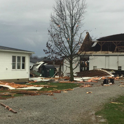
Damage was most significant at a dairy farm on state Route 136, about 1.3 miles south of Millers Chapel Road. A large barn at this property experienced a significant amount of roof damage, including a total loss of the roof on the east side of the structure. Insulation, wood beams and sheet metal from this roof were scattered across the property and well into a field across state Route 136. A roof was also removed from a dog kennel, and a roof was partially removed from another barn at the property. Other outbuildings had minor damage as well.
The house at this property sustained minor roofing damage and several broken windows, with some damage (and partial removal) of siding. Mud splatter was observed on several sides of both the main barn and the house. Trees were snapped or downed at this property, as well as along a tree line further to the west.
Tree damage occurred on Millers Chapel Road near the intersection with Poole Lane. A few other trees were snapped in the field just to the north of Poole Lane, but damage was not observed west of the end point of Poole Lane.
No fatalities or injuries have been reported due to any of the tornadoes.
Two of the tornadoes, one near Leesburg and one near Greenfield, were classified EF0 (wind speeds 65-85 miles per hour), while one later Wednesday morning near New Market was an EF1 (wind speeds 86-110 miles per hour).
According to the NWS, the first tornado touched down south of Leesburg around 2:31 a.m. Wednesday and lasted until approximately 2:39 a.m. The tornado’s path was 250 yards wide and seven miles long, and its maximum wind speed was 85 miles per hour.
[[In-content Ad]]
The following information was posted by the NWS about the Leesburg tornado:
Damage was first observed at a farm residence on the north side of Larkin Road, where one tree was downed and a barn was destroyed. Northeast of there, some minor tree damage was seen on state Route 72 and along tree lines in adjacent fields.
Structural damage occurred at a property on US Route 62 near the intersection with Old US 62, with several outbuildings destroyed or heavily damaged. The house at this location had minor damage, mainly to roofing materials, with shingles removed on multiple sides. One large evergreen tree was uprooted, and other trees were snapped. At another property slightly northeast on US Route 62, a garage was destroyed, and numerous trees behind the garage were snapped.
On Leaverton Road, a barn was partially collapsed. Two evergreen trees were snapped, and other tree damage was observed both at this location and across the field to the east. Slightly south of this location, also on Leaverton Road, several trees were downed along a low spot on the road, and a fence was blown flat. Minor tree damage was also observed where the tornado crossed Smith Road, and a garage door was blown in at a residence on State Route 771, with some trees snapped in the vicinity. A few trees were also damaged where the tornado crossed Monroe Road.
Tree damage was observed to be significant in several locations along Milner Road, which was still due to cleanup efforts just east of Monroe Road. A house on Milner Road sustained siding damage to both the east and west sides of the structure, and tree damage was extensive at this property. An adjacent modular home had its roof removed, and other outbuildings were damaged, with debris thrown northeast across an adjacent field. A few buildings at this property also exhibited signs of mud splatter.
A hay barn on Bridges Road had most of its top half removed, with the top also removed from another adjacent outbuilding. A home on Big Oak Road had part of its roof removed, with debris observed in an adjacent field, likely a result of damage further to the west.
The last observed damage from this tornado occurred along Cope Road, where an outbuilding was mostly destroyed, and a garage had part of its roof removed. Debris was thrown across Cope Road into a field to the east and southeast. There was no tree damage observed along the tree line to the east of Cope Road, so it is believed that the tornado caused no further damage beyond this point.
Just one minute after this tornado is believed to have ended, the National Weather Service confirmed that a tornado touched down near Greenfield. The tornado began at approximately 2:40 a.m. and ended around 2:45 a.m., with 65 mile per hour winds. The tornado’s width was 100 yards, and its length was 4.6 miles.
The following information has been provided by the NWS about the tornado near Greenfield:
One tree was downed at a residence north of the intersection of state Route 138 and Hardins Creek Road. Further north along State Route 138, several trees were snapped.
On Road T-319A, a small unanchored shed was completely removed from its slab, and a barn had part of its roof removed on both its northwest and southeast sides. In addition, some trees in this area were snapped.
The next observed damage was along state Route 753 about one mile north of the bridge over Rattlesnake Creek, with several snapped trees. A slightly more concentrated area of tree damage was observed on Paint Creek Road just to the west of Paint Creek. Some tall trees were snapped, and sheet metal debris from earlier damage was also found along Paint Creek Road.
To the west of Paint Creek in Ross County, no further damage was observed.
The final tornado, with the largest wind speed, began in New Market at approximately 7:39 a.m. and lasted until 7:41 a.m. This tornado had 95 mile per hour winds, with a width of 150 yards and length of 2.2 miles.
The following information was provided by the NWS about this tornado.
At a location on Sanders Road just west of US Route 62, a barn roof was significantly damaged, with roofing material thrown to the east as much as a half mile away. A few trees were downed in this area.
Damage was most significant at a dairy farm on state Route 136, about 1.3 miles south of Millers Chapel Road. A large barn at this property experienced a significant amount of roof damage, including a total loss of the roof on the east side of the structure. Insulation, wood beams and sheet metal from this roof were scattered across the property and well into a field across state Route 136. A roof was also removed from a dog kennel, and a roof was partially removed from another barn at the property. Other outbuildings had minor damage as well.
The house at this property sustained minor roofing damage and several broken windows, with some damage (and partial removal) of siding. Mud splatter was observed on several sides of both the main barn and the house. Trees were snapped or downed at this property, as well as along a tree line further to the west.
Tree damage occurred on Millers Chapel Road near the intersection with Poole Lane. A few other trees were snapped in the field just to the north of Poole Lane, but damage was not observed west of the end point of Poole Lane.
No fatalities or injuries have been reported due to any of the tornadoes.