


Storm tracking north of Highland County
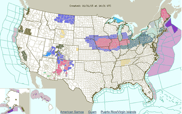
A hazardous weather advisory remains in effect for Highland and surrounding counties from late Saturday through Monday, Feb. 2, the National Weather Service said Saturday. However, earlier predictions by the NWS that the region could receive as much as 8-10 inches of snow have been revised.
The new forecast calls for a mix of rain, freezing rain and snow over the next two days.
New snow and sleet accumulation of less than a half inch is possible by early Sunday, Feb. 1, followed by additional snow and sleet before 8 a.m. Sunday, then changing to rain. The high on Super Bowl Sunday will be near 38.
Forecast
Sunday Night – Rain before 1am, then rain and snow likely between 1am and 3am, then a chance of snow after 3am. Low around 13. South wind 6 to 13 mph becoming northwest after midnight. Winds could gust as high as 30 mph. Chance of precipitation is 100%. New snow accumulation of less than one inch possible.
Monday – A chance of snow, mainly before 8am. Mostly cloudy, with a high near 21. Northwest wind 8 to 15 mph, with gusts as high as 25 mph. Chance of precipitation is 30%. New snow accumulation of less than a half inch possible.
Monday Night – Partly cloudy, with a low around 4.
Tuesday – Mostly sunny, with a high near 31.
Tuesday Night – Partly cloudy, with a low around 24.
Wednesday – Partly sunny, with a high near 38.
Wednesday Night – Mostly cloudy, with a low around 18.
Thursday – Partly sunny, with a high near 26.
Thursday Night – Partly cloudy, with a low around 5.
Friday – Mostly sunny, with a high near 20.
[[In-content Ad]]