


Hurricane Sandy expected to bring life-threatening storm surge flooding to Mid-Atlantic Coast
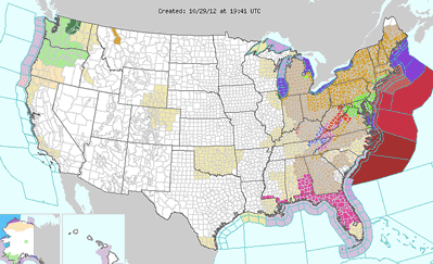
A very large and dangerous Hurricane Sandy continues to move parallel to the East Coast, with a turn to the northwest expected Sunday night and early Monday.
The National Weather Service said late Sunday that Sandy is expected to make landfall along the central New Jersey coast Monday evening.
In addition to long periods of sustained tropical storm-force winds, the storm will produce historic surge levels along the coast, the NWS said.
The storm also is expected to bring significant snowfall in the mountain areas of West Virginia and Virginia.
The southern Ohio forecast calls for a mix of rain and snow Sunday night, with a low around 35 degrees. Wind gusts could be as high as 31 mph. The chance of precipitation is 100 percent overnight.
• "With Hurricane Sandy moving into the eastern states, Highland and neighboring counties can expect the possibility of bad weather," said Jim Lyle, director of the Highland County Office of Homeland Security and Emergency Management Agency.
"The EMA office wants to remind the citizens of Highland County to prepare," Lyle said.
(Please see the accompanying sidebar for a list of emergency items or call the EMA office at 393-5880.)
[[In-content Ad]]
On Monday, expect some rain and snow early, becoming all rain after 10 a.m.
Monday's high will be 44, with gusts approaching 40 mph. The chance of precipitation Monday is 80 percent.
A mix of rain and snow is likely Monday night with a low around 35, with wind gusts near 50 mph.
Winds could exceed 55 mph on Tuesday, the National Weather Service said, with up to an inch of rain expected.
On Wednesday, there's a chance of rain and snow before 8 a.m., then a chance of rain, with a high near 44.
States of emergency have been declared from North Carolina to Connecticut.
The state of Delaware has ordered mandatory evacuations for coastal communities. Ocean City, Md. was also evacuated.
Authorities warned that New York City could be hit with an 11-foot wall of water that has the potential to swamp parts of lower Manhattan.