


Massive weekend winter storm set to begin
https://www.wpc.ncep.noaa.gov/
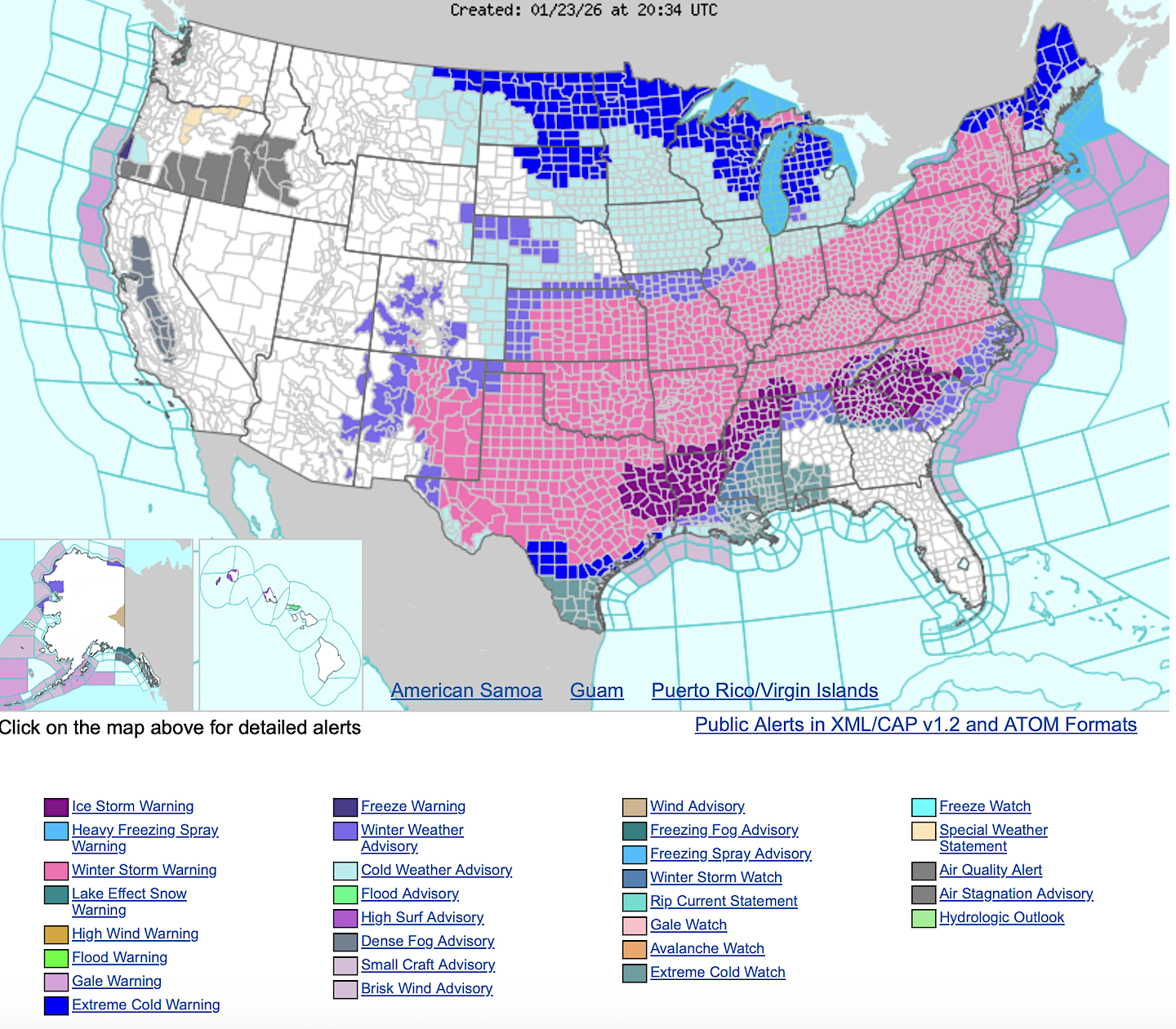
A significant winter storm is forecast to begin in the Southern Rockies and Central/Southern Plains today, progressing eastward through the Mid-South and into the Mid-Atlantic and the Northeast through Monday. This is expected to produce large swaths of heavy snow, sleet, and freezing rain, bringing hazardous driving conditions, power outages, and tree damage.
The heaviest snowfall is expected across a large area, including parts of the Southern Rockies, Plains, and through the Mid-Atlantic and Northeast. Snowfall totals are expected to exceed one foot in parts of these areas, and widespread travel disruptions are likely. South of the snow axis, widespread freezing rain and sleet are expected, affecting the Southern Plains, Lower Mississippi Valley, Tennessee Valley, and much of the Mid-Atlantic. Catastrophic impacts are expected where freezing rain totals exceed half an inch, with over an inch expected in parts of
Louisiana, Arkansas, Mississippi, and the Southern Appalachians.
After the passing of the winter storm, a strong arctic air mass originated from Canada will continue to bring frigid temperatures into the eastern two-thirds of the U.S. into early next week. Sub-zero low temperatures will spread from through these regions, and will be accompanied by gusty winds, bringing dangerously low wind chills.
The coldest wind chills may fall below -50F across the Northern Plains, and numerous other record lows are expected. These wind chills will pose a life-threatening risk of hypothermia and frostbite to exposed skin, and risks could be prolonged and exacerbated by power outages caused by the aforementioned winter storm. Cold temperatures are then expected to continue across much of the eastern two-thirds of the U.S. into early February according to a Key Message from the Climate Prediction Center.
Meanwhile along the Gulf coast, potentially strong thunderstorms are forecast in parts of southern Alabama, Mississippi, and the Florida panhandle on Sunday in the wake of a mid-level trough moving into the Gulf of America.
The progression of the trough will allow for a weak surface front to remain in place after the passage of the previously mentioned arctic front. After the front stalls, relative warm moisture advection is expected from the Gulf, and with present weak instability and mid-level support, strong to potentially severe thunderstorms are possible. The Storm Prediction Center is forecasting a Marginal Risk of severe thunderstorms on Sunday.
Comment
White death
Wilmington Walmart is even out of keto bread. It’s the end of the world as we know it.
••••Publisher's note: Snowmaggedon Fern. Good times.
Kroger run
I bought a pork tenderloin...
This map is torture for the color blind
Are we getting gale winds or a small craft advisory? Remember 2, 3, and 4 years ago? When we barely got a skiff of snow for 3 straight winters? I knew the tides would turn. Our first snow this season was November 10th...
••••Publisher's note: Definitely a small craft advisory. Buy milk, eggs, bread & beer. It's the law.