


JUST CHILLIN'
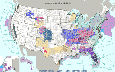
On top of another record low temperature this week, area residents are bracing for another round of snow and ice accumulation.
The National Weather Service in Wilmington has issued a Winter Storm Warning for Feb. 20-21. The NWS said 3 to 5 inches of new snow are possible, with some ice accumulations on the back side of the storm system.
The Friday morning low reached minus 11 degrees in Highland County, with wind chill values as low as -19.
A wind chill advisory remains in effect Friday, as all area schools closed for the fourth straight day.
Snow is expected to arrive late Friday and continue on Saturday. The chance of precipitation is 90%. New snow accumulation of 1 to 3 inches is possible with the initial band, followed by a mix of rain, snow, and sleet after 5 p.m. Saturday. The new snow and sleet accumulation is expected to be 1 to 3 inches.
[[In-content Ad]]
Forecast
Sunday – A slight chance of snow after 8 am. Partly sunny, with a high near 29. Northwest wind around 9 mph. Chance of precipitation is 20%.
Sunday Night – A slight chance of snow showers before 9pm. Mostly cloudy, with a low around 7. Chance of precipitation is 20%.
Monday – Partly sunny, with a high near 15.
Monday Night – Partly cloudy, with a low around -2.
Tuesday – Partly sunny, with a high near 25.
Tuesday Night – Mostly cloudy, with a low around 12.
Wednesday – Partly sunny, with a high near 25.
Wednesday Night – Mostly cloudy, with a low around 6.