


Winter storm warning in effect for Jan. 22-23
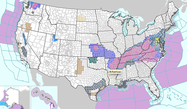
A vigorous winter storm system will be moving across southern Ohio and northern Kentucky Friday, Jan. 22 and Saturday, Jan. 23.
The National Weather Service has issued a winter storm warning for much of the region.
Total snow accumulation ranging from 4 to 6 inches is possible, with higher accumulations in some areas.
Snow is expected to begin falling on Friday afternoon and continue into Saturday morning.
[[In-content Ad]]
Forecast
Today – Mostly sunny, with a high near 27.
Tonight – Increasing clouds, with a low around 17.
Friday - Snow, mainly after 3 p.m. High near 29. Chance of precipitation is 80%. New snow accumulation of 1 to 2 inches possible.
Friday night – Snow, mainly before 2 a.m. Low around 23. Chance of precipitation is 100%. New snow accumulation of 2 to 4 inches possible.
Saturday – A slight chance of snow before 8 a.m. Mostly cloudy, with a high near 30.
Saturday night – Mostly clear, with a low around 6.
Sunday – Mostly sunny, with a high near 32 and a low around 20.
Monday – A chance of rain and snow, with a high near 39.
Monday night – Rain and snow likely before 11 p.m., then a chance of snow.