


Three new publications highlight county survey research initiatives
The Ohio Geological Survey has released three new publications that result from its recent research efforts. The variety of documents illustrates the broad constituency that the Survey supports, from the general public to industry to local governments.
A new open-file report, OFR 2015-1: Karst of the Hillsboro, New Market, New Vienna, and Leesburg Quadrangles, Ohio, details the locations of karst features in the vicinity of Hillsboro.
Karst features include sinkholes, disappearing streams, and springs and can affect infrastructure (roads, utilities) and buildings.
Produced as part of a grant project funded by the U.S. Geological Survey, Great Lakes Geologic Mapping Coalition, the report includes introductory text on the methodology and results of the study, as well as a 72-page map book featuring the area geology and locations of 644 verified and suspected karst features. The new OFR 2015-1 is a great resource for land-use planners and homeowners who seek to develop land in the Hillsboro vicinity, and it is available as a free download in PDF or for purchase on a CD-ROM, which includes all the data used to produce the map book.
[[In-content Ad]]
Released in conjunction with OFR 2015-1, the new GeoFacts 31: Ohio Karst offers readers a great introduction to karst terrain.
The two-sided fact sheet includes a definition and explanation of karst terrain and how its features shape the landscape and can affect the environment. Sinkholes, disappearing streams, and springs can impact land use potentially by damaging infrastructure and buildings or polluting groundwater. The new GeoFacts will be a useful reference for homeowners and young learners interested in Ohio’s geology.
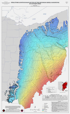
Finally, a new set of geologic maps may lead to further exploration of oil and gas resources in eastern Ohio. Map set PG-5: Structure Contour Maps on Top of the Silurian Dayton Formation, Devonian Onondaga Limestone, and Devonian Berea Sandstone in Eastern Ohio offers a look at three formations that may hold increased potential for development of petroleum and natural gas.
The maps also show possible structural features that were previously unmapped. Part of the Survey’s Digital Map Series, the PG-5 maps are available as print-on-demand products and in digital format on CD-ROM, which includes PDF versions of the maps and a full suite of digital data. These maps and data will be useful tools for exploration geologists as well as academics interested in tectonics and geologic structure.
For more information or to order copies of OFR 2015-1 or map PG-5, visit the Survey’s online store at ohiogeologystore.com or go to http://geosurvey.ohiodnr.gov/news-events/recent-news-events-and-features-archive/post/new-publications-highlight-survey-research-initiatives