


Proposed redistricting map would have kept Highland and neighboring counties together
Lead Summary
By
-
The Highland County Press
A retired mechanical nuclear engineer from Coshocton, Ohio has proposed a legislative redistricting map for Ohio which would have kept Highland County in the Third Congressional District, only with more of its neighboring counties.
An editorial by Robert Brems Sr., a citizen member of the Coshocton Tribune Editorial Board, appears in the Sept. 25 Zanesville Times-Recorder, www.zanesvilletimesrecorder.com/article/20110925/OPINION02/109250309.
In his editorial, Brems said, "The Republican-dominated redistricting committee for the state of Ohio has spit in the face of Ohio voters with their new, heavily partisan, grossly gerrymandered Ohio Congressional District map that already has passed the Ohio House of Representatives and the Ohio Senate.
"This gross misuse of political power is the reason most people have tuned out of the political process because it reeks of political self-interest, not the public's interest. This is not what the people want from their government."
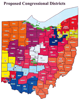
Brems, who says he is a lifelong registered Republican, said he was one of two people who provided testimony at the Redistricting Committee's public meeting July 20 in Zanesville. His proposed redistricting map, which also is available on the Ohio Secretary of State's website, places Highland, Adams, Brown, Clinton and Fayette counties (and others) in the same southwest Ohio Third Congressional District.
As reported in The Highland County Press, last week the Ohio Senate voted 24-7 to approve a bill that puts Highland County in the 15th Congressional district.
The proposed district plan places Highland County in the southwest corner of a horseshoe-shaped district. Other than a portion of Ross County to the east, all of Highland County's neighboring counties are in other districts in this proposal. Fayette County would be a part of the 10th District, while Clinton, Brown, Adams, Pike and a portion of Ross counties would be part of the Second District.
Ohio lost two Congressional districts following the 2010 census, due to slow population growth.
Ohio 17th District Sen. David Daniels (R-Greenfield) voted in favor of the bill as did 86th House District Rep. Cliff Rosenberger, R-Clarksville, who also represents Highland County.
"The map, I believe, meets the requirements of the Voting Rights Act, and it balances the districts," Daniels said. "As I began to look at the map to see what was possible, one of the things I tried to look at was 'What is this going to do to the counties in my district?' It kept quite a number of the counties whole, and I think that was an important part of my process."
However, Highland County Democratic Party Chairperson Dinah Phillips told The Highland County Press that she didn't feel the proposed map looked at the needs of the people in the districts.
"It's not fair to the people who they're supposed to be representing," Phillips said. "We have nothing in common (in the proposed 15th District) with the big industrial cities, and even the people. Their needs are not the same as the needs we have. We get overshadowed by the congressmen who represent the big district, which are composed of the large counties. They have more people, and therefore they tend to gravitate toward what those people need, and ignore us."
Daniels said that he feels Highland County can receive good representation in the 15th District.
"Ten years ago, when we went through the redistricting process, I think that most people, quite frankly, were upset we were put with Dayton and Montgomery County. We were put into sort of a metropolitan area 10 years ago, and now we're in a different metropolitan area," Daniels said.
"In the end, I think we voted on a fair and decent map," Rosenberger said. "The population of each district must be exactly the same. Ohio's Third Congressional District also had an urban center in Montgomery County, so it's kind of the same scenario here. Highland County is just with a different urban center (in Franklin County). The populations must be the same, and Highland had to be drawn like that."
Brems disagrees.
"The results of this redistricting expose the charade that was played before the people of having hearings around the state to get the public's input to the redistricting process," Brems wrote in the Times-Recorder. "Graphical online mapping tools were made available to the public by the Secretary of State's office to supposedly give the public a chance to draw their own maps and submit them for consideration. This was all a sham. The public certainly did not recommend anything like this monstrosity that will dominate Ohio politics for the next 10 years.
"While I was treated respectfully, listened to and questioned, I got the distinct impression that they merely were going through the motions," he said.
"I embarked on this endeavor as a lark," Brems said. "However, I am extremely disappointed and angered at the result, so much so that I have decided to close my checkbook to all Republican candidates and political organizations in the 2011 and 2012 election cycles. I also have chosen to drop my support for Senate Bill 5. I urge other disenchanted Republicans in Ohio to show their displeasure likewise…"
The Apportionment Board meets Monday, Sept. 26 to review the proposed maps. The board consists of four Republicans — Gov. John Kasich, Senate President Tom Niehaus, Auditor Dave Yost and Secretary of State Jon Husted — and one Democrat, House Minority Leader Armond Budish.[[In-content Ad]]
A retired mechanical nuclear engineer from Coshocton, Ohio has proposed a legislative redistricting map for Ohio which would have kept Highland County in the Third Congressional District, only with more of its neighboring counties.
An editorial by Robert Brems Sr., a citizen member of the Coshocton Tribune Editorial Board, appears in the Sept. 25 Zanesville Times-Recorder, www.zanesvilletimesrecorder.com/article/20110925/OPINION02/109250309.
In his editorial, Brems said, "The Republican-dominated redistricting committee for the state of Ohio has spit in the face of Ohio voters with their new, heavily partisan, grossly gerrymandered Ohio Congressional District map that already has passed the Ohio House of Representatives and the Ohio Senate.
"This gross misuse of political power is the reason most people have tuned out of the political process because it reeks of political self-interest, not the public's interest. This is not what the people want from their government."
Brems, who says he is a lifelong registered Republican, said he was one of two people who provided testimony at the Redistricting Committee's public meeting July 20 in Zanesville. His proposed redistricting map, which also is available on the Ohio Secretary of State's website, places Highland, Adams, Brown, Clinton and Fayette counties (and others) in the same southwest Ohio Third Congressional District.
As reported in The Highland County Press, last week the Ohio Senate voted 24-7 to approve a bill that puts Highland County in the 15th Congressional district.
The proposed district plan places Highland County in the southwest corner of a horseshoe-shaped district. Other than a portion of Ross County to the east, all of Highland County's neighboring counties are in other districts in this proposal. Fayette County would be a part of the 10th District, while Clinton, Brown, Adams, Pike and a portion of Ross counties would be part of the Second District.
Ohio lost two Congressional districts following the 2010 census, due to slow population growth.
Ohio 17th District Sen. David Daniels (R-Greenfield) voted in favor of the bill as did 86th House District Rep. Cliff Rosenberger, R-Clarksville, who also represents Highland County.
"The map, I believe, meets the requirements of the Voting Rights Act, and it balances the districts," Daniels said. "As I began to look at the map to see what was possible, one of the things I tried to look at was 'What is this going to do to the counties in my district?' It kept quite a number of the counties whole, and I think that was an important part of my process."
However, Highland County Democratic Party Chairperson Dinah Phillips told The Highland County Press that she didn't feel the proposed map looked at the needs of the people in the districts.
"It's not fair to the people who they're supposed to be representing," Phillips said. "We have nothing in common (in the proposed 15th District) with the big industrial cities, and even the people. Their needs are not the same as the needs we have. We get overshadowed by the congressmen who represent the big district, which are composed of the large counties. They have more people, and therefore they tend to gravitate toward what those people need, and ignore us."
Daniels said that he feels Highland County can receive good representation in the 15th District.
"Ten years ago, when we went through the redistricting process, I think that most people, quite frankly, were upset we were put with Dayton and Montgomery County. We were put into sort of a metropolitan area 10 years ago, and now we're in a different metropolitan area," Daniels said.
"In the end, I think we voted on a fair and decent map," Rosenberger said. "The population of each district must be exactly the same. Ohio's Third Congressional District also had an urban center in Montgomery County, so it's kind of the same scenario here. Highland County is just with a different urban center (in Franklin County). The populations must be the same, and Highland had to be drawn like that."
Brems disagrees.
"The results of this redistricting expose the charade that was played before the people of having hearings around the state to get the public's input to the redistricting process," Brems wrote in the Times-Recorder. "Graphical online mapping tools were made available to the public by the Secretary of State's office to supposedly give the public a chance to draw their own maps and submit them for consideration. This was all a sham. The public certainly did not recommend anything like this monstrosity that will dominate Ohio politics for the next 10 years.
"While I was treated respectfully, listened to and questioned, I got the distinct impression that they merely were going through the motions," he said.
"I embarked on this endeavor as a lark," Brems said. "However, I am extremely disappointed and angered at the result, so much so that I have decided to close my checkbook to all Republican candidates and political organizations in the 2011 and 2012 election cycles. I also have chosen to drop my support for Senate Bill 5. I urge other disenchanted Republicans in Ohio to show their displeasure likewise…"
The Apportionment Board meets Monday, Sept. 26 to review the proposed maps. The board consists of four Republicans — Gov. John Kasich, Senate President Tom Niehaus, Auditor Dave Yost and Secretary of State Jon Husted — and one Democrat, House Minority Leader Armond Budish.[[In-content Ad]]