


Big Chill turns southern Ohio frigid
Lead Summary
By
-
The calendar still says fall, but the temperatures suggest winter has made an early arrival here in southern Ohio and across the Midwest.
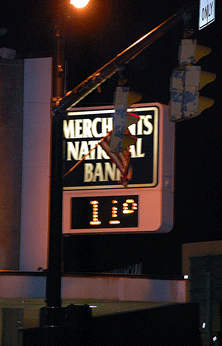
The temperature in Hillsboro early Tuesday morning was a brisk 11 degrees outside Merchants National Bank in the city's historic uptown business district.
The National Weather Service says we can expect scattered snow showers today, with a high near 22. This morning's wind chill values were as low as -3.
The total daytime snow accumulation is expected to be half an inch or less.
Extended Forecast
Tonight: Mostly cloudy, with a low around 10. Wind chill values as low as -1. West wind between 8 and 13 mph.
Wednesday: Mostly cloudy, with a high near 22. Wind chill values as low as -1. West wind between 7 and 9 mph.
Wednesday Night: Mostly cloudy, with a low around 11. West wind around 6 mph becoming calm.
Thursday: Partly sunny, with a high near 30. Calm wind becoming south between 5 and 8 mph.
Thursday Night: A chance of snow showers, mainly after 1am. Mostly cloudy, with a low around 26. Chance of precipitation is 40%.
Friday: A chance of snow showers before 8am. Mostly cloudy, with a high near 38. Chance of precipitation is 30%.
Friday Night: Mostly cloudy, with a low around 28.
Saturday: Mostly cloudy, with a high near 40.
Saturday Night: Rain and snow likely. Cloudy, with a low around 36. Chance of precipitation is 60%.
Sunday: Rain and snow likely. Cloudy, with a high near 37. Chance of precipitation is 60%.
Sunday Night: A chance of snow showers. Cloudy and breezy, with a low around 13. Chance of precipitation is 40%.
Monday: Mostly cloudy, with a high near 22.
The calendar still says fall, but the temperatures suggest winter has made an early arrival here in southern Ohio and across the Midwest.
The temperature in Hillsboro early Tuesday morning was a brisk 11 degrees outside Merchants National Bank in the city's historic uptown business district.
The National Weather Service says we can expect scattered snow showers today, with a high near 22. This morning's wind chill values were as low as -3.
The total daytime snow accumulation is expected to be half an inch or less.
Extended Forecast
Tonight: Mostly cloudy, with a low around 10. Wind chill values as low as -1. West wind between 8 and 13 mph.
Wednesday: Mostly cloudy, with a high near 22. Wind chill values as low as -1. West wind between 7 and 9 mph.
Wednesday Night: Mostly cloudy, with a low around 11. West wind around 6 mph becoming calm.
Thursday: Partly sunny, with a high near 30. Calm wind becoming south between 5 and 8 mph.
Thursday Night: A chance of snow showers, mainly after 1am. Mostly cloudy, with a low around 26. Chance of precipitation is 40%.
Friday: A chance of snow showers before 8am. Mostly cloudy, with a high near 38. Chance of precipitation is 30%.
Friday Night: Mostly cloudy, with a low around 28.
Saturday: Mostly cloudy, with a high near 40.
Saturday Night: Rain and snow likely. Cloudy, with a low around 36. Chance of precipitation is 60%.
Sunday: Rain and snow likely. Cloudy, with a high near 37. Chance of precipitation is 60%.
Sunday Night: A chance of snow showers. Cloudy and breezy, with a low around 13. Chance of precipitation is 40%.
Monday: Mostly cloudy, with a high near 22.
[[In-content Ad]]