


UPDATED: Winter weather advisory for Jan. 2
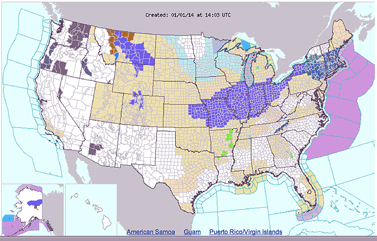
A new winter weather advisory for southern Ohio has been posted for the new year.
A storm system is expected to bring 2 to 3 inches of snow, beginning late Wednesday evening and into Thursday morning, according to the National Weather Service.
The advisory begins early Thursday morning and continues until 7 p.m. Thursday, Jan. 2.
Several area delays and closings have been announced. Go to: http://www.highlandcountypress.com/main.asp?SectionID=14&TM=20783.42
Additionally, bitter cold temperatures are in the forecast for Jan. 6-7. The overnight low on Monday, Jan. 6 is expected to be -1, with a daytime high on Tuesday, Jan. 7 of 14 degrees.
The New Year's Day forecast calls for partly sunny skies, with a high near 42.
Snow develops early Thursday morning. New snow accumulation of less than a half inch possible before sunrise.
On Thursday, temperatures will fall to around 20 by 5 p.m., with 2 to 3 additional inches of snow. Light north wind increasing to 10 to 15 mph in the morning. Chance of precipitation is 100%.
Extended forecast
Thursday Night – Snow showers likely, mainly before midnight. Cloudy, then gradually becoming partly cloudy, with a low around 11. Wind chill values as low as -3.
Friday – Mostly sunny, with a high near 21 and a low around 14.
Saturday – Sunny, with a high near 35 and a low around 26.
Sunday – Rain and snow. High near 36. Chance of precipitation is 80%.
Sunday Night – Snow likely. Cloudy, with a low around 13. Chance of precipitation is 70%.
Monday – Mostly cloudy, with a high near 18 and a low around -1.
Tuesday – A chance of snow showers. Partly sunny, with a high near 13.
[[In-content Ad]]