


Heat advisory in effect
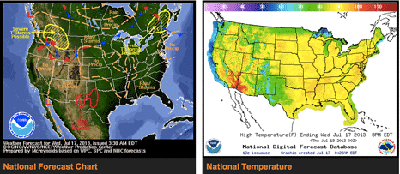
A heat advisory is in effect today for most all southwest Ohio and most of the state.
Wednesday's high temperature will be in the mid-90s, with a heat index near 105.
At 7 a.m. today, the temperature was already 75 degrees and had inched up to 83 by 10 a.m.
The National Weather Service issues a heat advisory if there is a heat index of at least 105°F but less than 115°F for less than three hours per day and/or if nighttime low temperatures are above 80°F for two consecutive days.
People are advised to drink plenty of fluids, stay out of the sun, remain in air conditioning when possible, and check up on neighbors and relatives.
The National Weather Service forecast calls for mostly sunny skies Wednesday, with a high near 94. Tonight's low will be around 71.
[[In-content Ad]]
Extended forecast
Thursday – Mostly sunny, with a high near 93. Heat index values as high as 102. Light and variable wind.
Thursday Night – Partly cloudy, with a low around 71. Light southwest wind.
Friday – A chance of showers and thunderstorms, mainly after 4pm. Mostly sunny, with a high near 90. Southwest wind 5 to 10 mph. Chance of precipitation is 30%. New rainfall amounts of less than a tenth of an inch, except higher amounts possible in thunderstorms.
Friday Night – A chance of showers and thunderstorms before 11pm, then a slight chance of showers and thunderstorms after 4am. Partly cloudy, with a low around 72. Chance of precipitation is 30%. New rainfall amounts of less than a tenth of an inch, except higher amounts possible in thunderstorms.
Saturday – A chance of showers and thunderstorms. Partly sunny, with a high near 87. Chance of precipitation is 50%.
Saturday Night – A chance of showers and thunderstorms. Mostly cloudy, with a low around 66. Chance of precipitation is 50%.
Sunday – Mostly sunny, with a high near 83.
Sunday Night – Partly cloudy, with a low around 63.
Monday – Mostly sunny, with a high near 83.
Monday Night – Partly cloudy, with a low around 64.