


Dangerous weather for parts of the Central and Southern U.S.
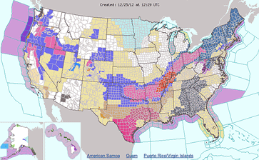
A storm system gathering strength in the South will bring a plethora of weather hazards to the U.S. on Christmas, the National Weather Service predicts.
Heavy snow and blizzard conditions will blanket parts of the Plains and Midwest creating treacherous driving conditions. Also, a severe weather outbreak is forecast through parts of the Gulf Coast States and Southeast, with long-track tornadoes possible.
This large storm system has prompted a winter storm warning that is in effect through at least midnight Tuesday for much of Oklahoma and Arkansas and parts of southern Missouri. By the time the storm is through, these areas could have between 4 to 6 inches of sleet and snow.
The National Weather Service also warns of possible tornadic activity in the Southeast.
The threat of severe storms may reach as far east as parts of Alabama, southeast Tennessee and western Georgia by Tuesday evening and could reach coastal South Carolina by early Wednesday.
A winter storm watch is in effect from Missouri through Vermont, a huge swath of territory where significant snows are expected to fall through Thursday.
For southern Ohio, the National Weather Service forecast calls for partly sunny skies on Christmas Day, with a high near 39. Freezing rain is expected to develop around 2 a.m. Wednesday, with an overnight low of 30 degrees. The chance of precipitation is 100 percent, with ice accumulation of 0.1 to 0.2 of an inch possible.
Wednesday will see a wintry mix of rain and snow before 1 p.m., then rain between 1 p.m. and 4 p.m., followed by light snow after 4 p.m. The high will be near 38. The chance of precipitation is 100 percent with new snow accumulation of 1 to 2 inches possible.
Snow is likely Wednesday night, mainly before 2 a.m., with a low around 25.
Thursday will be mostly cloudy, with a high near 33 and a low around 22.
Friday will be partly sunny, with a high near 35 and a low of 28.
[[In-content Ad]]