


Late-season winter storm expected to bring snow
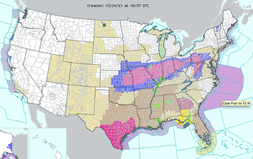
A late-season winter storm system has moved out of the Rockies and is tracking through the Central Plains and Midwest over the weekend.
A band of heavy snow from the Front Range of the Colorado Rockies through Indiana and Ohio will begin falling Sunday in the Ohio Valley.
Meanwhile, severe weather and heavy rainfall hit the Gulf Coast and Southeast on Saturday.
For southern Ohio, the storm is expected to bring a mix of rain, sleet and snow beginning Sunday, with most of the snow developing late in the day or overnight hours.
After a Saturday high of 48, Sunday's high will be near 34, with accumulating snow possible later in the day, the National Weather Service said.
The chance for precipitation Sunday is 90 percent. New snow and sleet accumulation of 1 to 3 inches is possible by evening, with more snow on Monday.
Some regions north of Wilmington could see 6-8 inches of snow.
Forecast
Sunday Night – Rain, snow, and sleet likely before 1 a.m., then snow. Low around 29.
Monday – Snow likely, mainly before 4 p.m. Cloudy, with a high near 34.
Monday Night – A chance of snow showers. Cloudy, with a low around 29.
Tuesday – A chance of rain and snow showers before 4 p.m., then a chance of rain showers. Cloudy, with a high near 39.
Tuesday Night – Mostly cloudy, with a low around 25.
Wednesday – Partly sunny, with a high near 42.
Wednesday Night – Partly cloudy, with a low around 26.
Thursday – Mostly sunny, with a high near 44.
Thursday Night – Mostly cloudy, with a low around 29.
Friday – A chance of rain and snow showers. Mostly cloudy, with a high near 48.
[[In-content Ad]]